


Product Information
What is Tatukgis editor?
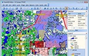
Professional desktop GIS supporting most ArcGIS (and other) data formats, enterprise spatial databases, 5,000 predefined coordinate systems, and a built-in script IDE for customization and functional expansion.
How to use Tatukgis editor?
TatukGIS Editor is a professional desktop GIS software that supports various ArcGIS and other data formats, enterprise spatial databases, predefined coordinate systems, and includes a built-in script IDE for customization and feature expansion.
Core Functions of Tatukgis editor
Script Support
3D Visualization
Usage Scenarios of Tatukgis editor
- Process ArcGIS and other GIS data formats
- Manage enterprise spatial databases
- Customize GIS functionalities
- Extend GIS software capabilities
- Apply predefined coordinate systems
Common Questions about Tatukgis editor
What does TatukGIS Editor do?
How do I use TatukGIS Editor?
What are the core features of TatukGIS Editor?
What are the use cases for TatukGIS Editor?